Peking University, March 4, 2025: A research team led by Professor Guo Qinghua from the School of Earth and Space Sciences at Peking University published a study titled “How many trees are there in China?” in Science Bulletin on February 6, 2025. The paper, with Professor Guo as corresponding author and Associate Researchers Cheng Kai and Yang Haitao as co-first authors, provides significant insights into China’s tree population: by 2020, the average tree density in China was approximately 689 trees per hectare, bringing the total number of trees in the country to around 14.26 billion—roughly 100 trees per capita.
Why it matters?
China has emerged as a pivot of the global push for environmental conservation due to its large-scale reforestation and ecological restoration projects. Yet, fundamental questions remain: How many trees are there in China? How are they distributed? The answers to them are central to forest resource management, ecological protection, and the response to global climate change.
Traditional manual plot sampling for forest surveys may not be applicable to estimating on a national scale, and thus it is necessary to put in place advanced techniques for tree population estimates.
What’s new?
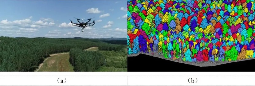
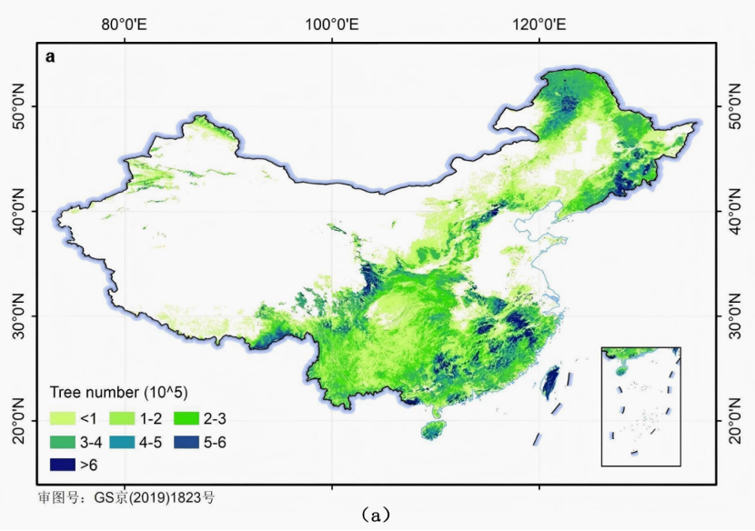
LiDAR technology and big data: Since 2015, Professor Guo’s team has been systematically collecting near-surface LiDAR data covering over 1,400 square kilometers and exceeding 400TB in volume (see Figure 1). By means of individual tree segmentation and multi-source data integration, they developed a multi-model ensemble learning algorithm to map out the tree density across China for the year 2020 at a resolution of 100 meters (see Figure 2).
Multi-scale and multi-dimensional analysis: Apart from providing statistics, the research also offers a multi-scale, multi-dimensional analysis of the intricate distribution of forest trees across the country.
Key findings
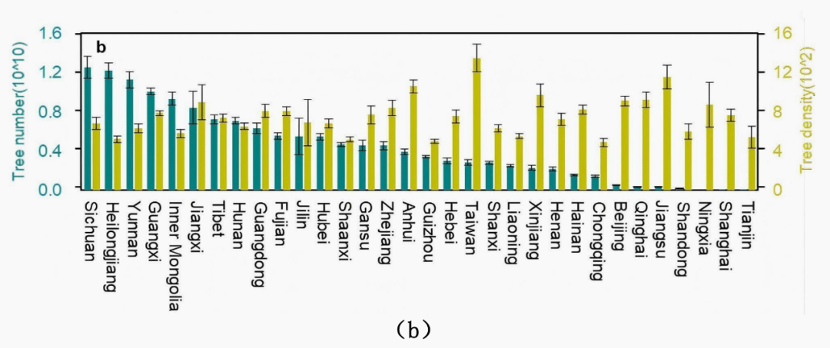
By vegetation zone: Cold temperate coniferous forests, with a density of 720 trees/ha, contributed over 60% of China’s total tree count (8.79 billion trees), whereas warm temperate deciduous broadleaf forests exhibited the highest density at 989 trees/ha.
By geographic region: The northeast, southeast, and southwest regions represented significantly higher numbers and densities of trees than the north and northwest. Specifically, the southwest region held the highest tree count at 3.6 billion.
By river basin: The Yangtze River basin topped the list with 496 million trees, while the southeast, southwest, and Pearl River basins each exceeded 1 billion.
By province: Sichuan, Heilongjiang, Yunnan, and Guangxi provinces were home to more than 1 billion trees each, accounting for 32% of the national total. Sichuan ranked first due to its terrain and climate conditions. Xizang led in per capita tree count with 1,982 ± 121 trees per capita, reflecting the disparity between the distribution of trees and inhabitants, which provides insights for resource management and ecological policies.
Figure 1: UAV-mounted LiDAR data collection and individual tree segmentation
Figure 2: Distribution of tree population and density in China
Significance
In response to the “Trillion Tree Campaign”, China is also working to plant, protect, and restore 70 billion trees over the next decade. This research provides solid scientific support by accurately mapping tree density nationwide, enabling more effective reforestation planning, improved planting and waste prevention. The integration of high-precision data and intelligent model ensures that trees are planted in optimal locations, maximizing ecological and economic benefits, presenting a “Chinese solution” for global sustainability and restoration.
Link to the paper: https://www.sciencedirect.com/science/article/abs/pii/S2095927325001434
Written by: He Yike
Edited by: Zhang Jiang
Source: PKU News (Chinese)